Getting There - Vermont to Alaska |

We left our home base of Rutland, Vermont, flew a short trip over the Adironacks
and cleared customs in Ottawa. From there it was flat for the next 2000 miles.
This phase of the trip was surprisingly scenic and enjoyable.
The canola blossoms in this picture were typical of much of Saskatchewan, but
the scenery through the other provinces was equally appealing, and the Canadian
people were very friendly and helpful. Canadian regulations require a minimum
altitude of 1000 feet, but that's fine for this kind of sightseeing. |
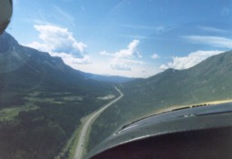
Once we reached British Columbia and the Alaska Highway, everything changed dramatically.
To a pilot, the Alaska Highway is a gigantic runway, offering a
suitable landing option for almost any kind of emergency. You can fly from
Vermont to Fairbanks without going any higher than 3000 feet above sea level,
and at higher altitudes you miss much of the scenery. Since airports were
rarely within gliding distance anyway, we just resigned ourselves to landing
on the highway if we an engine problem. |
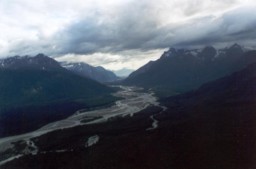
When not flying over roads, we would fly over rivers. Most of them had abundant
sand bars, which could serve as emergency landing fields if necessary.
This picture is very deceiving. What looks like mountain peaks are actually
the bases of the mountains, which rise another 10,000 feet above what you see here.
With ceilings of around 1000 feet like in this picture,we always got the feeling
that we were flying through tunnels, just wide enough to safely turn around in
if we had to, which on occasion we did. |
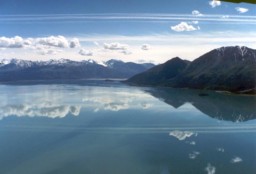
Weather, of course, was constantly changing. Here we are still on the Alaska
highway, somewhere in the Yukon with what seemed like clear flying ahead.
It was not unusual to have this kind of weather then shortly later be weathered
in someplace for days. |
Next: McCarthy |
12/27/04 6/27/08 |